
01
Earth observation inputs
Observe
Bring together satellite, radar, climate, terrain and environmental signals for the area that matters.
Earth observation intelligence
Satellite and AI intelligence for infrastructure, climate risk, natural resources and environmental monitoring — turning Earth observation data into decision-ready insight.
Observe
Satellite + environmental data
Detect
AI + change analysis
Prioritise
Risk + decision intelligence
From observation to decision
Earth's AI turns Earth observation into operational intelligence: observe conditions, detect meaningful change and deliver clear priorities for teams that need to decide what happens next.
Earth observation inputs
Bring together satellite, radar, climate, terrain and environmental signals for the area that matters.
AI + geospatial analytics
Use AI-assisted change detection, hazard screening and risk scoring to turn pixels into evidence.
Decision intelligence
Prioritise assets, locations and interventions with maps, rankings, statistics and report-ready outputs.
Commercial intelligence
Flood intelligence
Screen flood exposure and affected assets with decision-ready satellite intelligence and priority outputs.
Hazard intelligence
Active fire monitoring with satellite and AI, area selection, charts and operational outputs.
Infrastructure intelligence
Identify exposed infrastructure assets and prioritise resilience screening using Earth observation and AI.
Ground deformation intelligence
Screen and prioritise surface-movement signals for assets, corridors and infrastructure monitoring.
Insurance intelligence
Screen property and portfolio exposure to environmental hazards with ranked risk intelligence.
Mining intelligence
Screen mine and tailings facilities for surface change, water, rainfall, terrain and erosion signals.
Live demo apps
Filter the full Earth's AI catalog by operational domain, then open any workflow directly in your browser.
Infrastructure intelligence
InfrastructureRank possible dam-site zones using terrain, water proximity, rainfall, land-cover suitability and satellite AI scoring.
Water intelligence
Water & ClimateSatellite and AI reservoir monitoring with map layers, time series and Excel reporting.
Water quality
Water & ClimateSatellite and AI algae monitoring for water-quality screening, monthly map layers and reports.
Water intelligence
Water & ClimateCompare turbidity, algae signal, water clarity and water extent using satellite and AI indicators.
Rainfall intelligence
Water & ClimateAnalyse rainfall totals, intensity and heavy-rainfall areas with maps, charts and reporting.
Cryosphere intelligence
Water & ClimateAnalyse monthly snow cover, snow extent and persistent snow areas with satellite layers and charts.
Flood intelligence
Water & ClimateScreen flood exposure and affected assets with decision-ready satellite intelligence and priority outputs.
Flood intelligence
Water & ClimateMap flood-risk signal using terrain, optical satellite, radar satellite and AI scoring.
Flood intelligence
Water & ClimateDetect possible flood signal using satellite and AI with map layers, charts and Excel reporting.
Climate intelligence
Water & ClimateMap monthly drought-risk signal using satellite and AI with layers, charts and reporting.
Hazard intelligence
HazardsActive fire monitoring with satellite and AI, area selection, charts and operational outputs.
Wildfire intelligence
HazardsMonitor wildfire activity and affected areas across Europe with satellite-based fire intelligence.
Hazard intelligence
HazardsMap monthly fire-risk signal using satellite and AI with layers, charts and reporting.
Fire intelligence
HazardsPrioritise fire exposure and asset risk using satellite, environmental and geospatial signals.
Fire intelligence
HazardsDetect burned-area signal using satellite and AI with map layers, area statistics and reporting.
Terrain hazard intelligence
HazardsMap landslide-risk signal using optical satellite, radar satellite, terrain and AI.
Infrastructure intelligence
InfrastructureIdentify exposed infrastructure assets and prioritise resilience screening using Earth observation and AI.
Utility intelligence
InfrastructureScreen utility assets for environmental hazards and rank locations for inspection and intervention.
Rail infrastructure
InfrastructureScreen rail corridors for heat-related buckling risk using environmental and geospatial intelligence.
Ground deformation intelligence
InfrastructureScreen and prioritise surface-movement signals for assets, corridors and infrastructure monitoring.
Insurance intelligence
Industry & RiskScreen property and portfolio exposure to environmental hazards with ranked risk intelligence.
Mining intelligence
Industry & RiskScreen mine and tailings facilities for surface change, water, rainfall, terrain and erosion signals.
Marine intelligence
Industry & RiskDetect suspected dark slicks using radar satellite signals, land masking and AI scoring.
Environmental intelligence
Industry & RiskCombine environmental and geospatial signals for location-based outbreak screening and decision support.
Environmental intelligence
Land & CitiesMonitor monthly air-quality signal using satellite and AI with map layers, charts and reporting.
Forest intelligence
Land & CitiesMonitor forest-loss risk using optical and radar satellite data with AI-assisted change analysis.
Land intelligence
Land & CitiesMonitor water, urban, forest, crop, vegetation and bare-soil change using satellite and AI.
Land-cover AI
Land & CitiesClassify land cover with a Random Forest workflow and generate map-based class summaries.
Urban nature intelligence
Land & CitiesMap monthly urban vegetation using satellite and AI with urban masking, layers, charts and reports.
Urban climate intelligence
Land & CitiesMonitor monthly urban heat-island signal using satellite and AI with map layers and charts.
Agriculture intelligence
AgricultureMonitor monthly crop-health score using satellite and AI with map layers, charts and reporting.
Agriculture intelligence
AgricultureDetect bare soil inside cropland using satellite and AI with map layers and reporting.
Agriculture intelligence
AgricultureMonitor monthly relative soil moisture with satellite and AI, area drawing, charts and reports.
Agriculture intelligence
AgricultureMonitor monthly soil-salinity risk using satellite and AI with map layers, charts and reporting.
Land degradation intelligence
AgricultureMap erosion risk using terrain, bare-soil, vegetation-cover, rainfall and wetness indicators.
Forest intelligence
Land & CitiesTrain LiDAR-derived canopy-height models from Sentinel-1 and Sentinel-2 and explore AI-estimated forest structure in 3D.
Forest intelligence
Land & CitiesGenerate a synthetic 3D forest point cloud from Satellite + LiDAR training, with coloured tree instances and PLY export.
Earth intelligence, delivered differently
Start with a live workflow or request a custom analysis for your area of interest, operational question and reporting needs.
Earth Intelligence Product Tree
Explore EarthsAI capabilities across land, hazards, agriculture, water, risk, suitability and decision-ready outputs.
Core engine
Earth Observation + AI
AOI Requesting
Satellite Screening
GIS Statistics
Decision Reports
Capabilities
Start with a boundary. Choose the intelligence product. Receive map-based evidence, area statistics and decision-support notes.

Water • Risk • Impact
Satellite-based flood extent and surface-water screening for selected areas of interest.
● Flood extent screening
● Water-change evidence
● AOI area statistics
Land • Habitat • Change
Land-cover mapping and area summaries for vegetation, water, bare land, built-up areas and agriculture.
● Class summaries
● GIS-ready outputs
● Decision-ready outputs
Fire • Burn scar • Recovery
Post-fire screening for burn scars, vegetation loss and landscape recovery monitoring.
● Burn scar screening
● Vegetation impact
● Before/after evidence

Before • After • Evidence
Compare dates to identify surface-water, land-cover, vegetation or disturbance change.
● Date comparison
● Change statistics
● Decision-support notes
First Demo
Earth's AI used satellite data and AI to detect algal bloom in Lough Neagh, Northern Ireland. Our real-time model identified approximately 70 km² of algal bloom, showing how Earth Observation and AI can support early warning and water-quality management in real time.
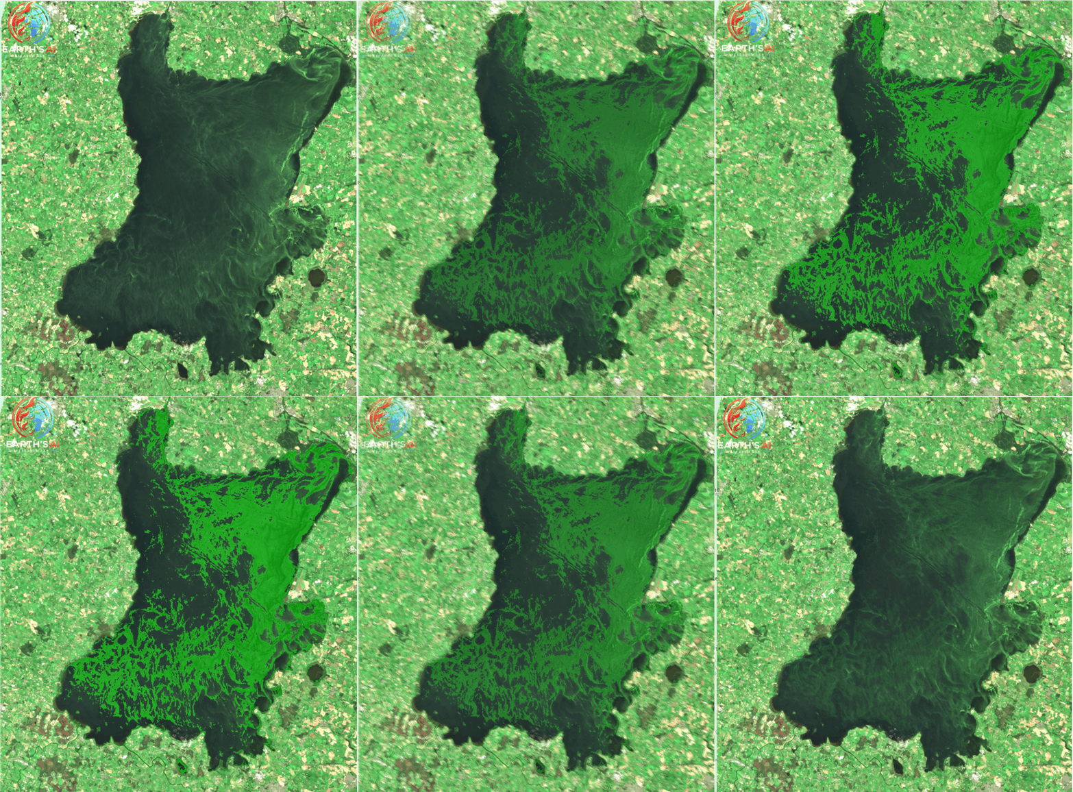
Water quality monitoring demo
Real-time satellite monitoring and AI can help identify bloom extent and support early intervention.
Water Intelligence
Recurrent blooms in Lough Neagh are linked to nutrient runoff, rising water temperatures and ecosystem changes. This demo shows how Earth's AI can turn satellite imagery into actionable water insights.
✓ Detection of ~70 km² of algal bloom
✓ Real-time satellite + AI monitoring
✓ Support for early warning systems
✓ Improved water-quality management
Earth Observation for aquatic ecosystems
This approach demonstrates how satellite monitoring and AI can provide rapid environmental intelligence for lakes, reservoirs and coastal waters, helping decision-makers respond faster to water-quality risks.
Flood Intelligence
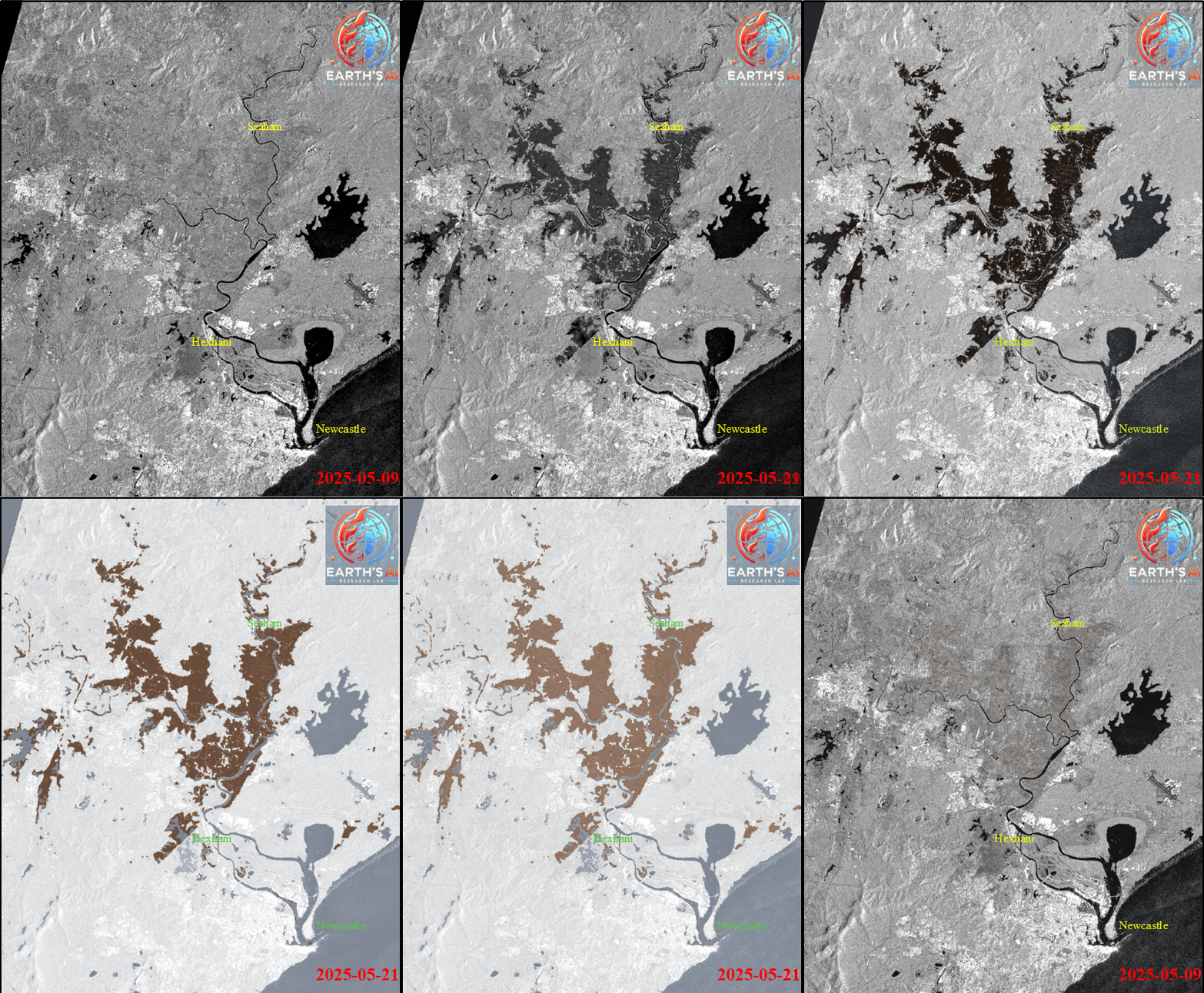
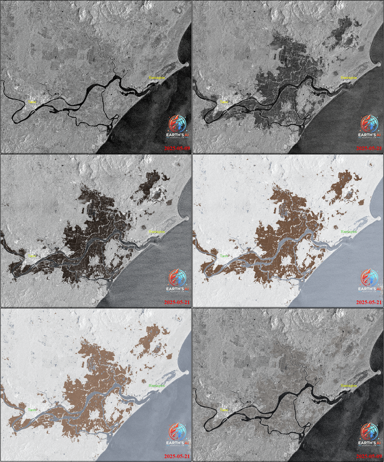
On 21 May 2025, Earth's AI detected a significant flood event across parts of Australia's Hunter and Mid-North Coast, particularly impacting Newcastle and Taree, using satellite imagery and advanced AI analysis.
Following intense rainfall, the region experienced widespread flooding and emergency rescues. Earth's AI mapped flood extent in high detail and can generate precise inundation maps for other affected regions on request.
✓ High-detail flood extent mapping
✓ Inundation mapping for affected regions
✓ Support for emergency response and situational awareness
✓ Rapid satellite-based analysis for resilience planning
Real-time geospatial intelligence for climate extremes
As climate extremes become more common, near-real-time geospatial intelligence is critical for rapid response and resilience planning. Satellite data and AI can help responders understand where flooding is occurring and where further analysis is needed.
Hedgerow Intelligence
Earth's AI detected hedgerow areas in Oxfordshire during winter 2025 using satellite imagery and AI-powered analysis.
This example shows how winter imagery can support hedgerow mapping, boundary identification and landscape monitoring. Our workflow helps identify linear vegetation features and can support comparison across different dates and locations.
✓ Hedgerow detection from satellite imagery
✓ Winter-season vegetation mapping
✓ AOI-based environmental screening
✓ Support for monitoring change over time
Request hedgerow analysis
Earth's AI can provide hedgerow detection and change monitoring for your area of interest using satellite data and AI-assisted analysis.
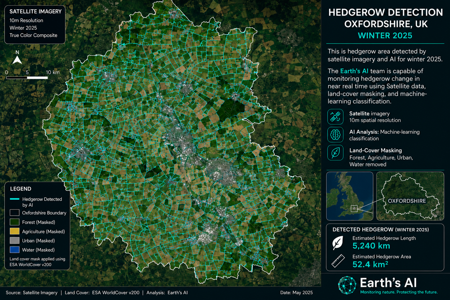
Hedgerow detection case study
Detected in winter 2025 in Oxfordshire using satellite imagery and AI.
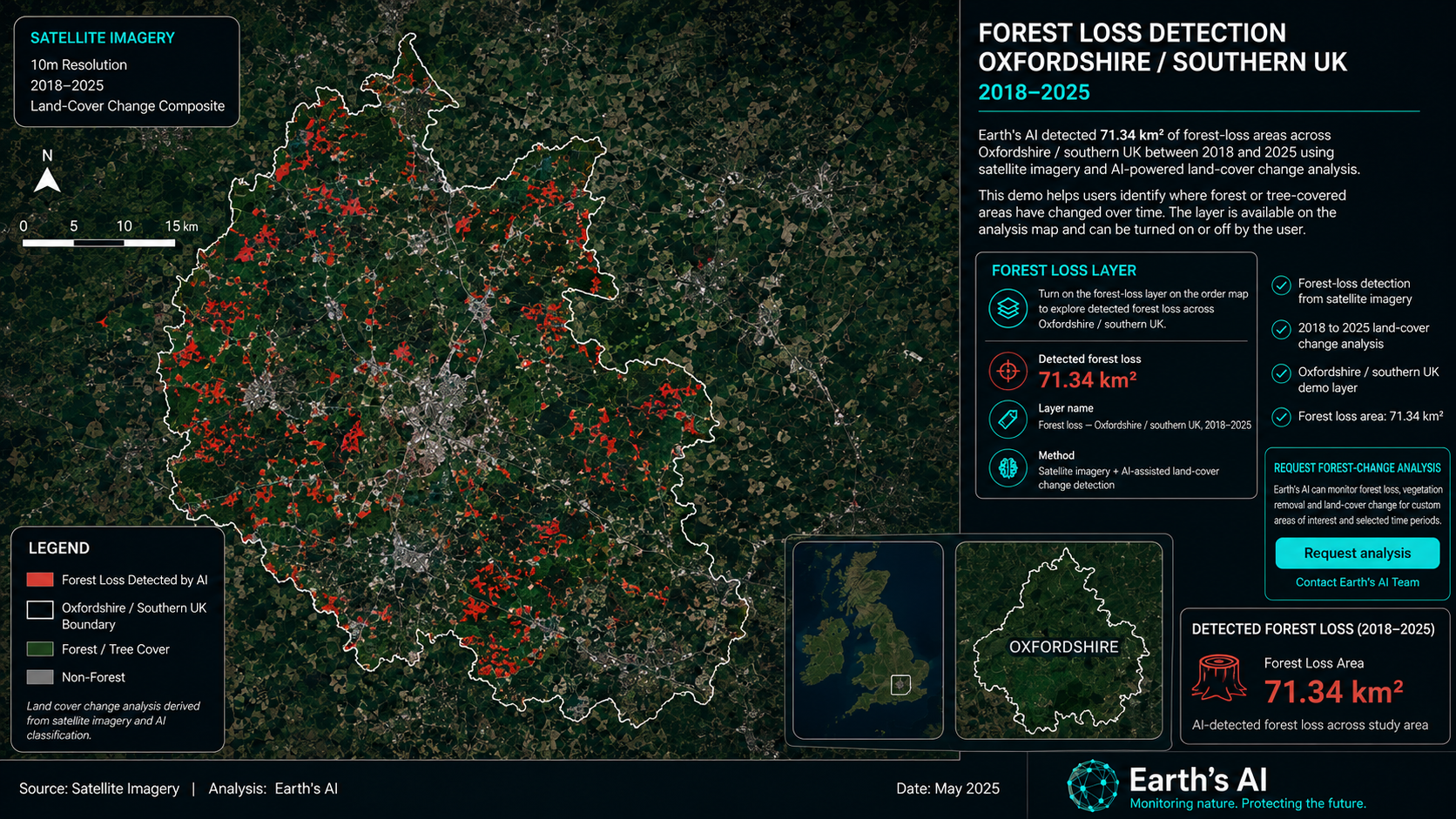
Forest loss demo layer
Detected forest loss across Oxfordshire / southern UK, 2018–2025: 71.34 km².
Forest Change Intelligence
Earth's AI detected 71.34 km² of forest-loss areas across Oxfordshire / southern UK between 2018 and 2025 using satellite imagery and AI-powered land-cover change analysis.
This demo helps users identify where forest or tree-covered areas have changed over time. The layer is available on the analysis map and can be turned on or off by the user.
✓ Forest-loss detection from satellite imagery
✓ 2018 to 2025 land-cover change analysis
✓ Oxfordshire / southern UK demo layer
✓ Forest loss area: 71.34 km²
Request forest-change analysis
Earth's AI can monitor forest loss, vegetation removal and land-cover change for custom areas of interest and selected time periods.
Land-cover Change Intelligence
This demo shows areas in London where vegetation changed to urban or built-up land between 2018 and 2025.
Detected using satellite imagery and AI-assisted land-cover change analysis by Earth's AI.
✓ Vegetation area reduced by 123.94 km²
✓ Urban area increased by 87.32 km²
✓ 2018 to 2025 land-cover comparison
✓ Layer available on the analysis map
Request land-cover change analysis
Earth's AI can detect vegetation loss, urban expansion and land-cover change for your selected area of interest and date range.
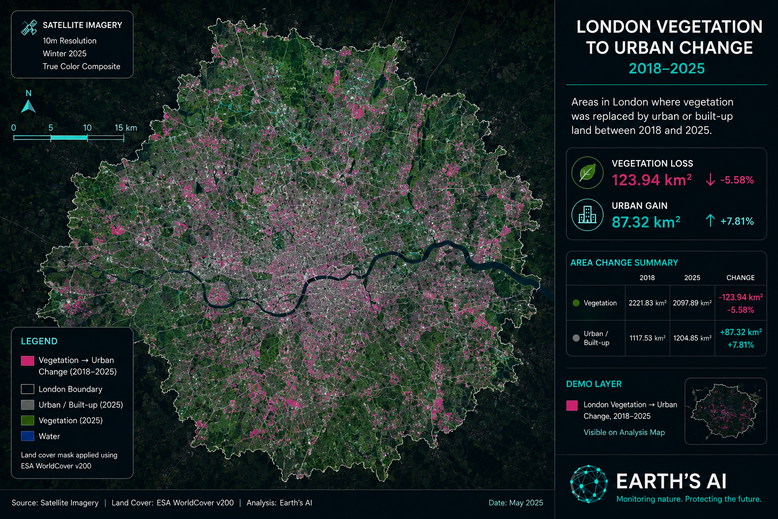
Area change summary
Vegetation change
-123.94 km²
-5.58%
Urban change
+87.32 km²
+7.81%
Demo layer
Turn on “London vegetation → urban change, 2018–2025” in the analysis map to view the detected change layer.
Wildfire Intelligence
Between 11 and 16 August 2025, Earth's AI detected and tracked the rapid progression of wildfires across Spain, with spillover impacts in Portugal. Small fire outbreaks expanded quickly under record heat and dry conditions.
Within days, the fires spread dramatically, surpassing 300,000 hectares burned and continuing to grow. Near-real-time monitoring revealed the scale of the disaster and how quickly extreme weather can escalate wildfire risk.
✓ Near-real-time wildfire progression monitoring
✓ Burned-area and hotspot intelligence
✓ Situational awareness for emergency response
✓ Support for early warning and climate resilience planning
AI-driven wildfire monitoring for extreme weather risk
Wildfire risk is no longer only a seasonal concern. AI-powered Earth observation can support firefighters, policymakers and communities with high-resolution, data-driven insights during fast-moving climate disasters.
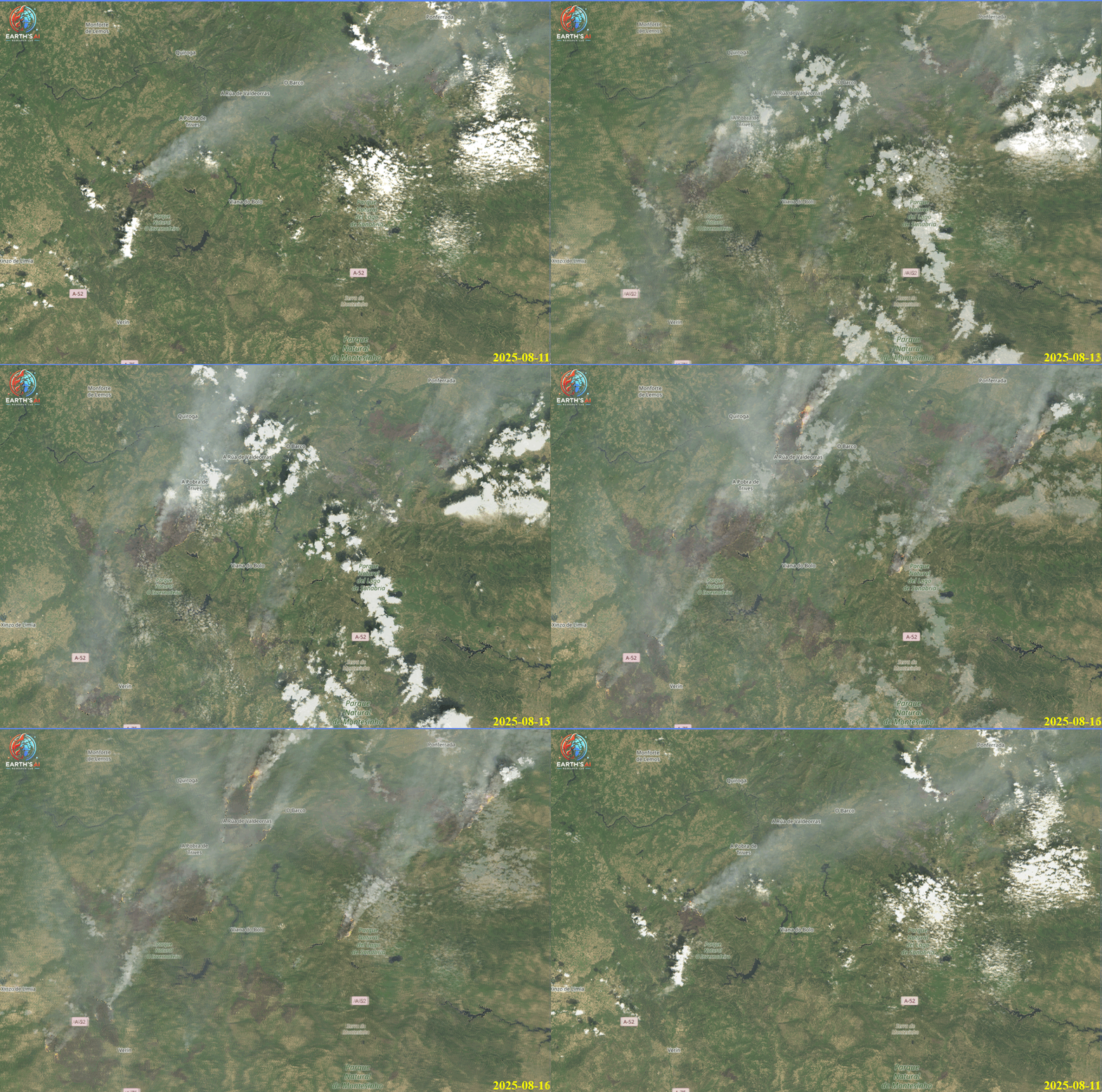
Wildfire monitoring case study
AI-powered Earth observation can reveal wildfire spread, burned area and rapidly evolving risk during major fire events.
Agriculture Intelligence
Earth's AI introduces a ready-to-use Ploughed Field Detection Tool for agricultural planning and monitoring. Using satellite imagery and AI-driven analytics, the tool helps identify ploughed areas, compare field patterns across years and support data-driven land management.
✓ View ploughed areas across different years
✓ Compare field sizes and trends over time
✓ Select areas of interest and analyze field data
✓ Generate actionable reports for better decisions
Built for agricultural planning and management
This product helps users detect ploughed fields efficiently and make informed decisions for agricultural monitoring, planning and reporting. Customers can define an area of interest and request analysis for selected locations and time periods.
Ploughed field detection product
Satellite imagery and AI can help monitor agricultural activity, field preparation and land-management trends across time.
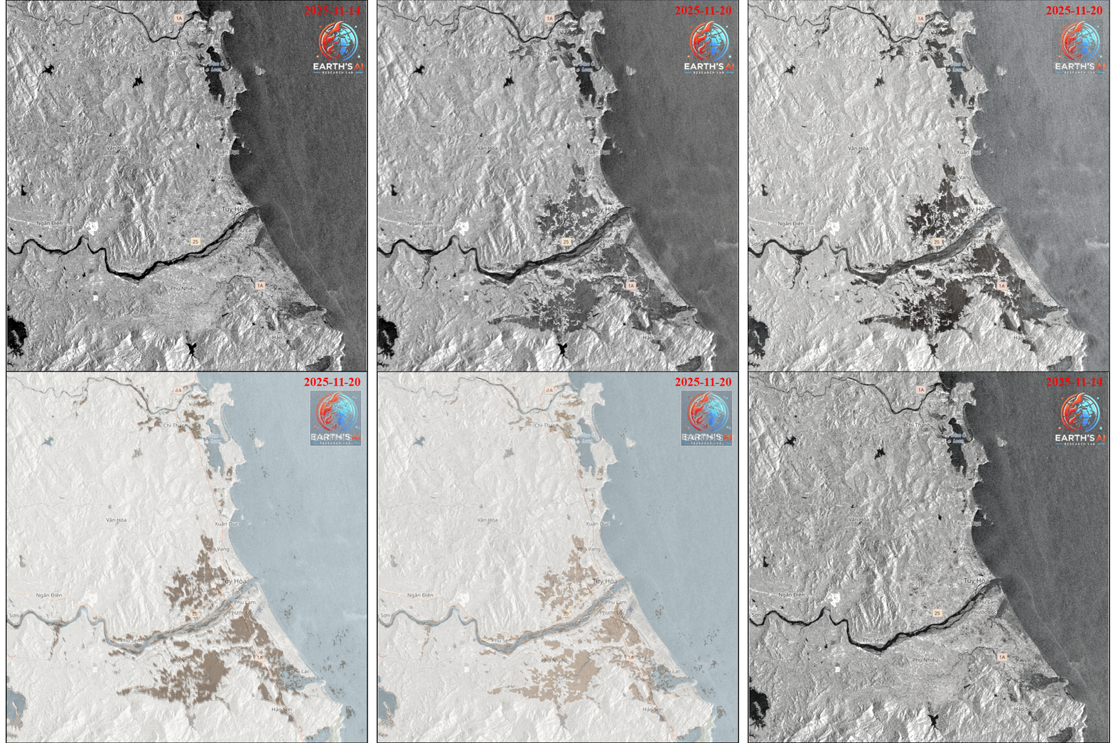
Flood mapping case study
Satellite imagery and AI-assisted flood mapping can help identify submerged areas, affected routes and priority zones when field access is limited.
Flood Intelligence
Disaster date: November 2025
Following days of intense rainfall, Vietnam experienced severe flooding across multiple provinces. Earth's AI Team used satellite imagery and AI-assisted flood-mapping workflows to monitor flood extent and support situational awareness.
✓ Identification of submerged villages and transportation routes
✓ Assessment of affected cropland and infrastructure
✓ Prioritization guidance for rescue and relief teams
✓ Data-driven situational awareness for authorities
Climate resilience and rapid response
When ground conditions are inaccessible, satellite-based AI can provide rapid and consistent visibility. Earth's AI is building practical Earth intelligence tools to help governments, humanitarian agencies and communities prepare for and respond to climate-driven disasters.
Add a verified news/source link before publishing final disaster figures such as casualties, damaged homes or livestock losses.
Wildfire Intelligence
Earth's AI has been closely monitoring the Ventura, California wildfire using artificial intelligence and satellite imagery. The fire began in early July, covering approximately 121 km².
On 3 August, high winds and the risk of incomplete extinguishment contributed to reignition, expanding the fire to 208 km². By 8 August, satellite analysis showed it had surged to 439 km². This fast-moving brush fire, known as the Canyon Fire, forced evacuations in Ventura and Los Angeles counties.
✓ Near-real-time fire perimeter mapping
✓ Wildfire growth tracking and hotspot intelligence
✓ Situational awareness for emergency response
✓ Growth forecasting for decision-makers
Current situation
Extreme heat and low humidity accelerated fire spread across mountainous terrain. Hundreds of personnel, helicopters, bulldozers and air tankers were deployed, with evacuation orders remaining in place. Earth's AI provides near-real-time wildfire intelligence to support responders and operational planning.
Wildfire monitoring case study
AI-driven monitoring provides near-real-time fire perimeter mapping, wildfire growth tracking and operational situational awareness.
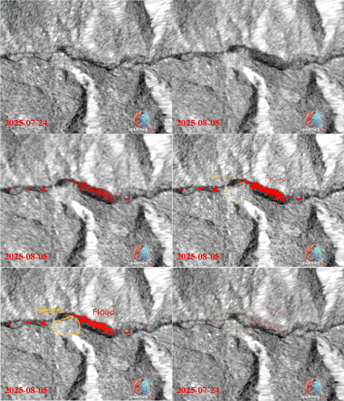
Flash flood case study
AI and satellite imagery can rapidly identify flooded zones and debris-affected areas after flash-flood disasters.
Flood Intelligence
A devastating flash flood struck the Himalayan town of Dharali, Uttarakhand, on 5 August 2025, sweeping away homes, roads and lives. Triggered by an intense cloudburst, the event caused widespread destruction.
Using satellite imagery and AI-powered Earth observation tools, Earth's AI analyzed the event within hours. Flooded areas were detected from satellite imagery before and after the event.
✓ Red areas indicate flooded zones caused by significant radar signal loss due to water
✓ Orange areas highlight debris-affected zones linked to landslides and mudslides
✓ Rapid damage mapping for disaster response and risk assessment
✓ Near-real-time situational awareness from AI + Earth Observation
AI + satellite data for rapid damage mapping
This is a clear example of how AI and satellite data can support early damage mapping, disaster response and risk assessment in real time, especially in mountainous environments where field access is difficult.
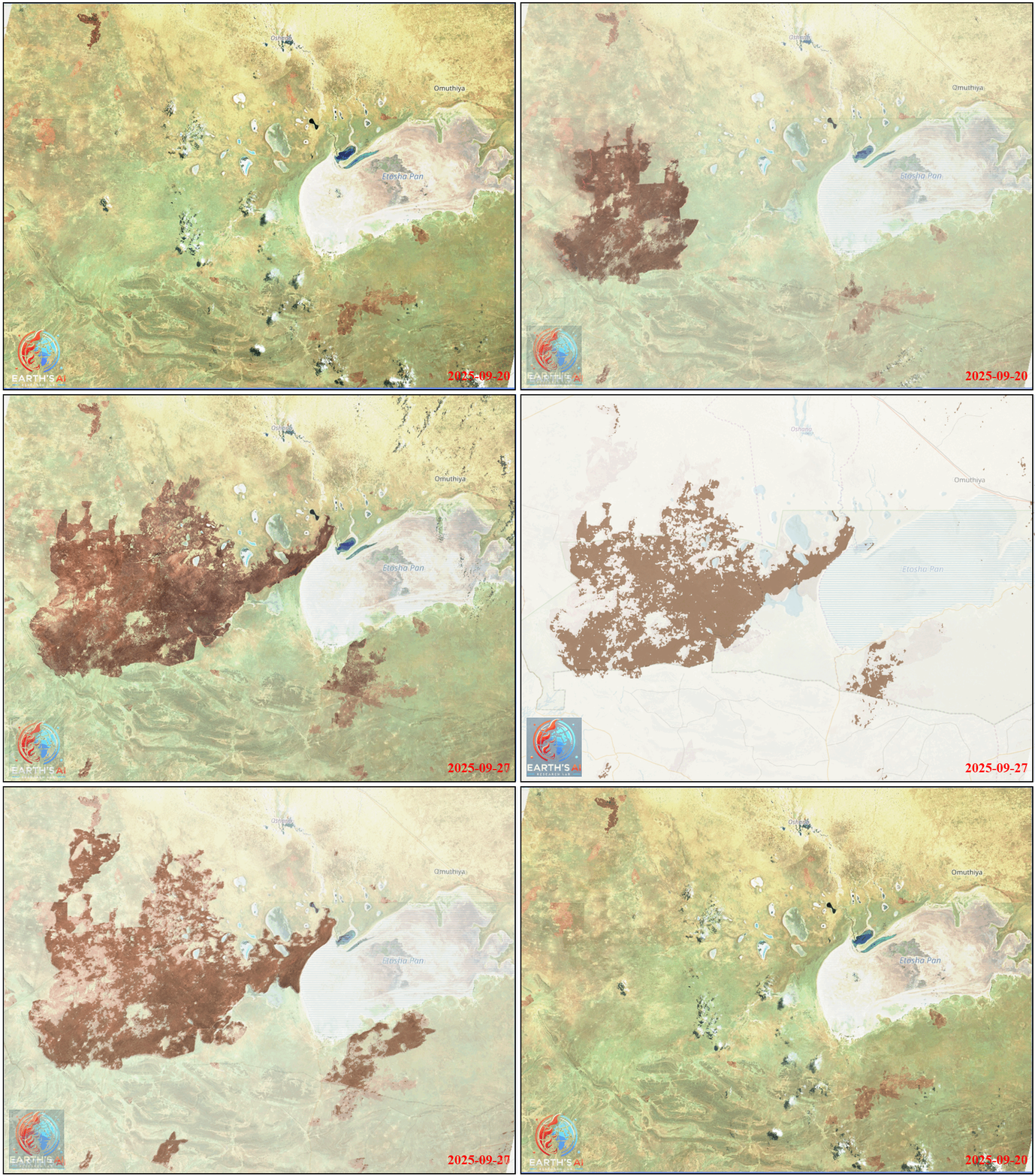
Wildfire monitoring case study
AI-powered fire detection and satellite monitoring can help track fire progression, burned area and active hotspots across protected ecosystems.
Wildfire Intelligence
Earth's AI monitored wildfire progression in Namibia during September 2025 using satellite imagery and AI-driven analytics. Severe wildfires swept through Etosha National Park, one of Africa's largest and most biodiversity-rich protected areas.
The wildfire began on 22 September 2025, burning more than 775,000 hectares inside the parkand another 171,000 hectares outside it. Emergency teams, volunteers and local communities worked to contain the flames amid difficult terrain and limited resources.
✓ Rapid hotspot detection
✓ Fire spread analysis
✓ Burned-area and damage assessment
✓ Support for conservation and ground response teams
Earth Observation + AI for wildfire response
As climate pressures increase wildfire frequency and intensity, integrating Earth Observation and AI is becoming essential for protecting ecosystems, wildlife and local communities.
Flood Intelligence
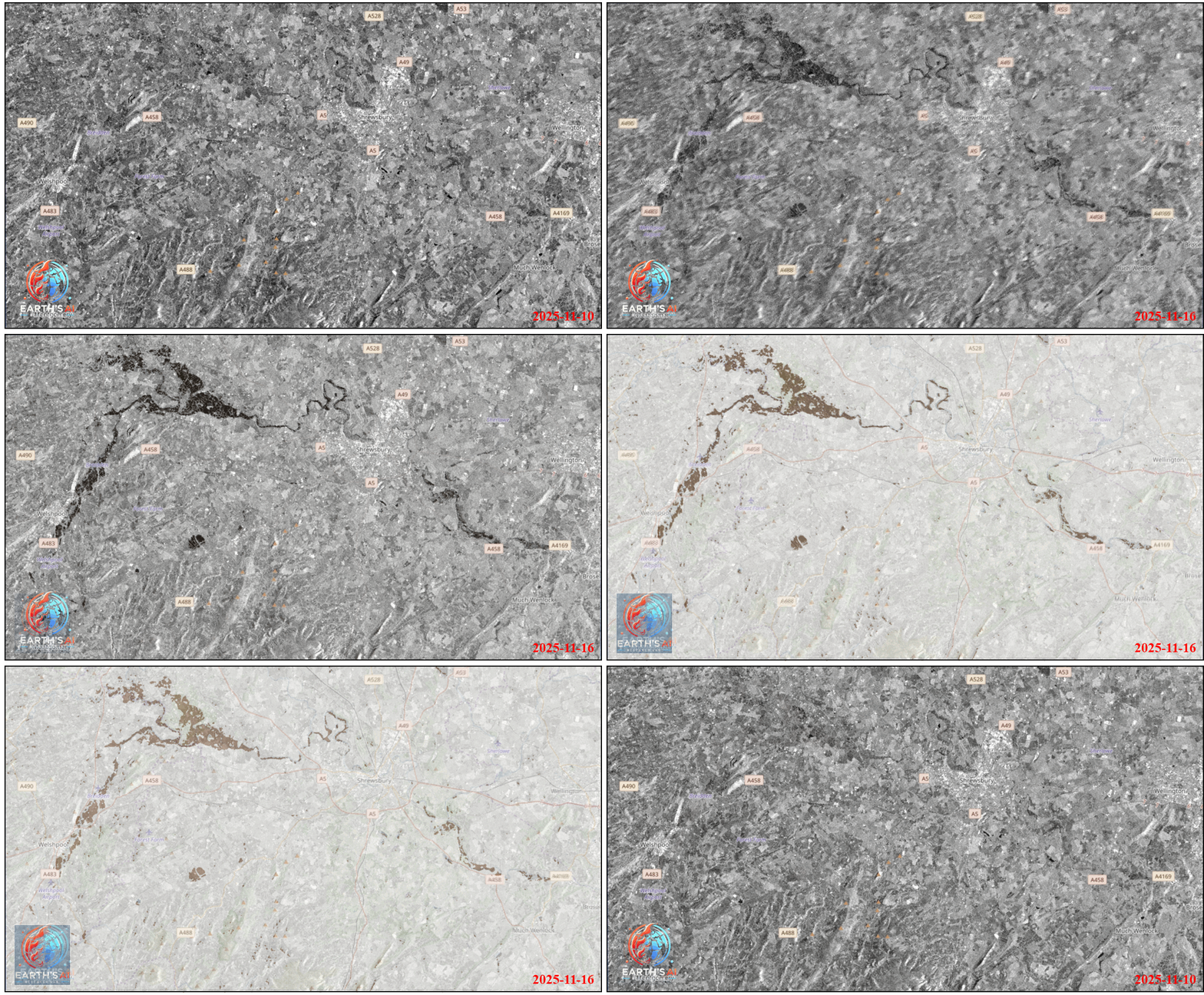
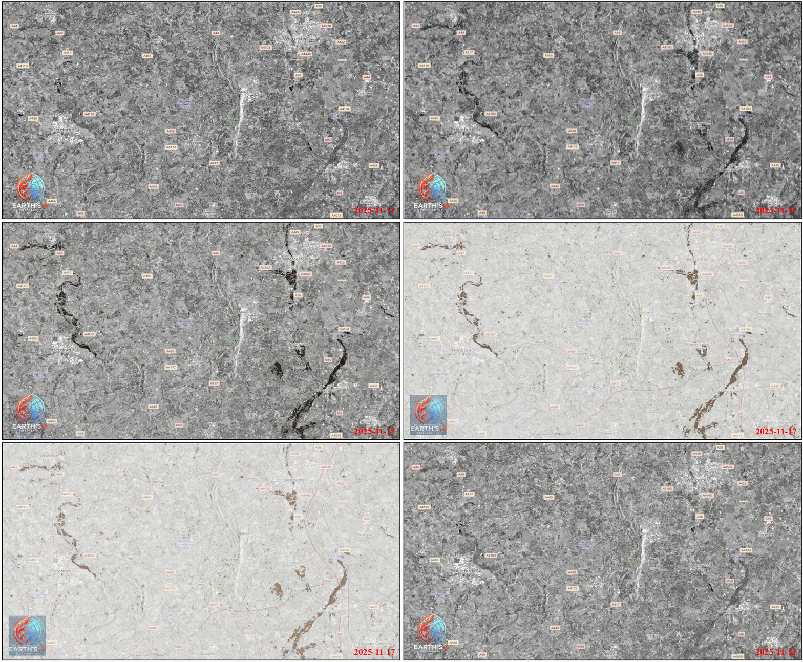
Earth's AI detected flood impacts from Storm Claudia across the UK in near real-time using AI-driven flood detection and satellite imagery. Severe flooding affected communities across the UK, with major incidents declared in parts of Wales.
In Monmouth, widespread inundation left homes without power and forced evacuations as the River Monnow burst its banks. Transport networks across Wales and England were disrupted, with rail services cancelled and hazardous-travel warnings issued.
✓ Near-real-time flood detection
✓ Identification of flooded settlements and routes
✓ Situational awareness for emergency responders
✓ Support for resilience planning and recovery
AI + satellite data for rapid flood response
Emergency teams responded to flood-related incidents using boats and rescue equipment to support residents. Events like Storm Claudia show the value of combining AI with satellite data for rapid disaster detection, flood mapping and resilience planning.
Built for practical decisions
Earth's AI is designed for customers who need satellite-based evidence without managing complex geospatial software. The platform captures the AOI, product type and project request so analysis can be prepared and delivered clearly.
Draw on the map or upload GeoJSON / zipped Shapefile.
Starting price calculated by square kilometre.
Maps, statistics and report-ready evidence.
A specialist can check outputs before customer delivery.
Process
01
Draw on the map or upload your boundary file.
02
Flood, land cover, wildfire or change detection.
03
Area is calculated in km² with instant starting price.
04
Earth's AI prepares your satellite screening report.
Pricing
Standard screening starts from £10 per km². Advanced modelling, urgent delivery, specialist datasets or complex areas may require a custom quote.
Request analysisStandard
£10/km²
AOI-based satellite screening.
Custom
Quote
Specialist data or larger projects.
Demo
Free
Open map and define AOI.
Ready for tasking?
Use the order map to define your project area, calculate the starting price and submit your request.
Open analysis mapRefund & Cancellation Policy
Earth's AI provides custom remote-sensing and geospatial analysis based on the area of interest, date range and application selected by the customer. Each request is reviewed before work begins.
You may cancel your request before analysis work has started. If you have already paid and we have not started the custom analysis, we will normally issue a full refund.
Because our outputs are prepared specifically for your selected AOI, date range and application, refunds may not be available once custom analysis has started or once digital outputs have been delivered, unless the output is faulty, not as described, or not delivered as agreed.
If the delivered analysis is faulty, materially different from what was agreed, or not delivered, contact us so we can review the issue. Where appropriate, we may correct the output, redeliver the analysis, offer a partial refund, or issue a full refund.
Earth's AI outputs are provided for remote-sensing screening, environmental intelligence and decision-support. They do not replace statutory ecological surveys, official flood-risk assessments, wildfire safety assessments, planning surveys or professional site investigations.
This policy does not limit your statutory rights under UK consumer law.